


- 5:10 h
- 16.12 km
- 458 m
- 502 m
- 1,312 m
- 1,520 m
- 208 m
- Start: Oberwald, train station
- Destination: Reckingen, train station
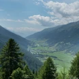
As a comfortable one-day route of the Gommer forest path, the section from Oberwald to Reckingen is recommended. The forest provides shade for the hiker while sun-drenched villages and dreamy hamlets lie down in the valley.

Good to know
Pavements
Best to visit
Directions
We start at Oberwald train station, then pass through the village of the same name and the neighboring hamlet of Unterwassern, before turning right onto a hiking trail that leads us south. On our way, we pass Obergesteln, catch a glimpse of Ulrichen and Münster-Geschinen, and finally descend to Reckingen.
Equipment
We recommend:
- Good footwear and hiking poles
- Sun and rain protection as well as warm clothing
- Detailed map or info material with good route preparation
- Provisions for your day in the great outdoors
- First-aid kit and mobile phone for emergencies
Directions & Parking facilities
From Brig, follow the cantonal road no. 19 (Furka Road) for about 40 km to Oberwald.
The Goms is also well connected from the Zurich / Lucerne region via Andermatt - Furka car shuttle www.matterhorngotthardbahn.ch.
With the regional trains of the Matterhorn Gotthard Bahn, you can reach Oberwald from Brig in 1h 23 min. The Goms is also easily accessible from the Zurich / Lucerne region via Andermatt - Furka Base Tunnel.
Timetables for trains and buses can be found at www.sbb.ch.
Additional information
Literature
At the tourist information offices and in most hotels and restaurants in Obergoms, you will find the following brochures:
- Obergoms summer map with hiking, cycling, and biking trails
- Holiday guide
Author´s Tip / Recommendation of the author
The Gommer Pass of the Matterhorn Gotthard Bahn entitles the holder to free travel on the Oberwald - Fiesch Feriendorf route in 2nd class.
Safety guidelines
Use of the hiking trails is at your own risk. Obergoms Tourismus AG assumes no liability and takes no responsibility for the accuracy and completeness of the information on this website.
Carry a hiking map with you or download the complete description of the hiking trail with a large-scale map. Use only signposted paths and observe all markings and signposts – for your own safety, to protect the landscape, and out of respect for wildlife. Be considerate towards other trail users. Take your waste and others' waste with you.
Weather conditions in the mountains can change very quickly and without warning. Appropriate clothing and sufficient provisions (food and drink) are very important. In case of unstable weather, it is better to turn back early.
Carry additional sun protection. UV rays at high altitudes can be very strong, even when the sky is overcast.
Plan your route carefully and thoroughly. Inform yourself in advance about the current conditions and weather. The summer report provides valuable information from the region.
Map
Hiking map Goms, Rotten Verlag, 1:25,000
Topographic maps 1:25,000 Swisstopo: 1250 Ulrichen
Nearby
