


- 1:00 h
- 3.12 km
- 6 m
- 49 m
- 1,312 m
- 1,361 m
- 49 m
- Start: Münster, train station
- Destination: Reckingen, train station
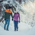
As a separate tour or in combination with other sections of the extensive winter hiking trail network in Goms, this tour is considered a special treat for nature lovers. Across the snow-covered mats, you enjoy the vastness of the valley and yet feel safe among the alpine mountain ranges.
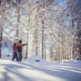
The well-prepared trail runs not far from and practically parallel to the cross-country tracks of the Loipe Goms. The Jematten bridge over the young Rhone is used in partnership by both winter hikers and cross-country skiers to cross the flowing water.
A look back is worthwhile. The mountain village of Münster makes a particularly beautiful photo motif from the Matte. The mighty Galenstock towers as a silhouette in the background.
At Überrotten you enter the mountain village of Reckingen. A detour to the magnificent Walliser Stadel, built in 1617, is recommended. The old agricultural building is considered a valuable witness to traditional Valais architectural culture and even serves as a photo spot for the Grand Tour in summer.

Good to know
Pavements
Best to visit
Directions
Tour information
Stop at an Inn
Equipment
- Good footwear and walking sticks
- Sun and rain protection and warm clothing
- Detailed map or information material with good tour preparation
- Provisions for your day in the great outdoors
- Pocket pharmacy and mobile phone for emergencies
Directions & Parking facilities
The Goms valley is also easily accessible from direction Zurich / Lucerne via Andermatt – car transport Furka .
The Alpine passes Furka, Grimsel and Nufenen are closed in winter.
The timetables for all trains and busses can be found at www.sbb.ch.
Additional information
- Winter sports report at www.obergoms.ch/winter-report
- Time table www.sbb.ch
- Telephone number of rescue service: 144
- Avalanche bulletin and snow situation at www.slf.ch
Literature
- Winter map of Obergoms with cross country trail plan
- Holiday companion
Author´s Tip / Recommendation of the author
Safety guidelines
Take a map with you or download the complete description of the route with a large-scale map. Use only signposted paths and observe all markings and signs - for your own safety, for the protection of the landscape and in respect for wildlife. Be considerate of other users. Take your rubbish and that of others with you.
Weather conditions in the mountains can change very quickly and without warning. Adequate clothing and provisions (food and drink) are very important. If the weather is unstable, it is better to turn around early. Carry additional sun protection with you. UV rays at high altitudes can be very strong, especially in winter, even when the sky is overcast.
Plan your tour carefully and in detail. Inform yourself in advance about the current conditions (avalanche danger, cross-country ski runs, winter hiking trails, snow trails and road conditions) and weather conditions. The winter sports report provides you with valuable information from the region.
Map
- Hiking map, Rotten Verlag, 1:25‘000
- National maps 1:25'000 Swisstopo: 1250 Ulrichen / 1270 Binntal
Nearby
