


- 2:30 h
- 8.26 km
- 36 m
- 847 m
- 1,352 m
- 2,205 m
- 853 m
- Start: Grimsel Pass, bus stop
- Destination: Obergesteln train station
The old pack animal route leads from Grimsel Pass down into the Rhone Valley to Obergesteln. You repeatedly come across sections where the old road surface (natural paving or large coverings with stone slabs) is still preserved. The path is now part of the Sbrinz route. The old trade route led from Lucerne over Lake Lucerne, up the Hasli Valley to the Grimsel, and then down to Obergesteln.

Good to know
Pavements
Best to visit
Directions
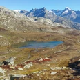
From the large car park near the hotels on the Bern side of the Grimsel Pass, you walk past the marmot park and then down to the left to the lake. The path runs along the southwestern shore of the lake on the flat opposite slope. With barely noticeable incline, the path leads to the highest point (2,205 m above sea level) and from here down into the valley to Obergesteln.
Tour information
Cultural Interesting
Stop at an Inn
Equipment
We recommend:
- Good footwear and hiking sticks
- Sun and rain protection as well as warm clothing
- Detailed map or information material with good route preparation
- Provisions for your day in the open nature
- First aid kit and mobile phone for emergencies
Directions & Parking facilities
From Brig follow the cantonal road No. 19 (Furka road) for about 40 km to Oberwald.
From here follow route No. 6 for 6 km to Grimsel Passhöhe.
The Goms is also well connected from the Zurich / Lucerne region via Andermatt - Furka car shuttle train www.matterhorngotthardbahn.ch.
- Parking available at the Grimsel Pass.
- Parking available at Oberwald train station.
With the regional trains of the Matterhorn Gotthard Bahn, you can get from Brig to Oberwald in 1h 23 min. The Goms is also easily accessible from the Zurich / Lucerne region via Andermatt - Furka base tunnel.
Timetables for trains and buses can be found at www.sbb.ch.
Change in Oberwald to the PostAuto Grimselpass line to the Grimsel Passhöhe stop.
Additional information
Literature
In the tourist information offices as well as in most hotels and restaurants in Obergoms, you will find the following brochures:
- Obergoms summer map with hiking, cycling and biking routes
- Holiday guide
Author´s Tip / Recommendation of the author
Around the Grimsel Pass, there are various offers and attractions:
- Furka steam railway
- Gelmer funicular
- and much more
Safety guidelines
Use of the hiking trails is at your own risk. Obergoms Tourism AG accepts no liability and takes no responsibility for the accuracy and completeness of the information on this website.
Carry a hiking map with you or download the complete description of the hiking trail with a large-scale map. Use only marked paths and observe all signs and signposts - for your own safety, for the protection of the landscape, and out of respect for wildlife. Behave considerately towards other trail users. Take your waste and the waste of others with you.
Weather conditions in the mountains can change very quickly and without warning. Appropriate clothing and sufficient provisions (food and drink) are very important. In unsettled weather, it is better to turn back early.
Carry additional sun protection. UV rays at high altitude can be very strong, even on cloudy days.
Plan your trip carefully and thoroughly. Inform yourself beforehand about the current conditions and weather. The summer report provides valuable information about the region.
Map
Hiking map Goms, Rotten Verlag, 1:25,000
Topographic maps 1:25,000 Swisstopo: 1250 Ulrichen
Nearby

