 Fiescheralp zur Riederalp")
 Fiescheralp zur Riederalp")
 Fiescheralp zur Riederalp")
- 3:15 h
- 9.07 km
- 63 m
- 343 m
- 1,878 m
- 2,218 m
- 340 m
- Start: Fiescheralp, mountain station Fiesch cable car - Fiescheralp
- Destination: Riederalp West
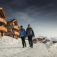
The starting point is the mountain station of the Fiesch cable car – Fiescheralp. From there, you hike in a westerly direction. Passing the deeply snow-covered alpine pastures and slopes of Martisberger and Laxeralp, you reach the Herrenweg to the restaurant Bättmer-Hitta. There follows a short ascent towards Wurzenbord, where a magnificent view of the mountain world awaits you. The winter hiking trail now leads downhill again, past the Möriken storage house to the Hotel Aletsch. Follow the village street through Bettmeralp in a westerly direction to the mountain station of the Bettmeralp cable car. Along the way, you pass the chapel Maria zum Schnee and typical Valais chalets. Continuing along the Aletsch promenade towards Riederalp West. On this section, there are hardly any more altitude meters to overcome. Numerous benches invite you to rest, enjoy, and recharge your energy.
The route consists of several sections. Please check the status open/closed in the winter sports report.

Good to know
Pavements
Best to visit
Directions
Fiescheralp - Restaurant Bättmer-Hitta - Bettmeralp - Riederalp
Tour information
Stop at an Inn
Equipment
We recommend:
- Good footwear
- Weather-dependent (waterproof) and warm clothing
- Head covering
- Sunscreen
- Provisions
- Camera
- Hiking poles (optional)
- Printout of the hiking trail (click "Print" to download)
Directions & Parking facilities
Additional information
Aletsch Arena AG
Furkastrasse 39
CH-3983 Mörel
+41 27 928 58 58
info@aletscharena.ch
www.aletscharena.ch
Literature
Author´s Tip / Recommendation of the author
Safety guidelines
Use of the winter hiking trails and information on this website is at your own risk. Conditions on site may cause changes to the route.
- Carry a map with you. Download the complete description of the hiking trail including a large-scale map by clicking "Print" at the top right of the page.
- Use only marked hiking trails and follow all signs and instructions – for your own safety, to protect livestock, and without disturbing the peace of wildlife.
- Be considerate towards other trail users and the landscape. Take your trash and others' trash with you.
- Carry additional sunscreen. UV rays at high altitudes can be very strong, especially in winter, even with overcast skies.
- Plan your hike carefully: consider the required fitness of all participants, weather forecasts, and seasonal factors.
- Weather conditions in the mountains can change very quickly and without warning. Appropriate clothing and sufficient provisions (food and drink) are very important. In uncertain weather, turn back early.
- Do not venture onto glaciers without a mountain guide.
- Observe warning signals indicating danger, especially avalanche danger.
- Inform third parties about your route and, if possible, never hike alone.
Note(s)
Due to altitude and trail routing, good footwear is absolutely essential for this winter hike.
Nearby

