


- 4:40 h
- 23.23 km
- 914 m
- 914 m
- 1,932 m
- 2,491 m
- 559 m
- Start: Bettmeralp, Hotel Aletsch
- Destination: Bettmeralp, Hotel Aletsch
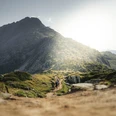
Start at Hotel Aletsch on Bettmeralp and run eastward. Before the forest edge turn right to avoid the busier hiking trails. The trail now leads 5.6 km through a wooded area to Fiescheralp. From there, you run on a wide natural road with a slight but constant ascent to Märjela, where you can enjoy the view of the Märjelen Lake and the Great Aletsch Glacier. The next section leads below Bettmerhorn and Hohbalm to Biel. The route is partly technically demanding, with constant glacier views but also incredibly beautiful! Tip: Take time repeatedly to enjoy the impressive panorama. Upon arrival at Biel, you run past Blausee and Bettmersee back to Bettmeralp. Be sure to enjoy the views of the Matterhorn and the impressive Valais mountain world on the other side of the valley here.

Good to know
Pavements
Best to visit
Directions
Tour information
Loop Road
Stop at an Inn
Equipment
We recommend:
- Light running backpack (about 5 to 10 liters) with rain cover
- Trail running shoes
- Weather-appropriate and breathable layered clothing
- Trail running poles (optional)
- Sun and rain protection
- Snacks and drinking water
- First aid kit
- Pocket knife
- Mobile phone
- Maps
Directions & Parking facilities
Additional information
Aletsch Arena AG
Furkastrasse 39
CH-3983 Mörel-Filet
+41 27 928 58 58
info@aletscharena.ch
www.aletscharena.ch
Literature
Author´s Tip / Recommendation of the author
Get the Aletsch Explorer Pass! With the combined mountain railway and train ticket, you are fully mobile in the Aletsch Arena!
Safety guidelines
Use of the trail running paths and information on this website is at your own risk. Local conditions may possibly cause changes in the route. Aletsch Arena AG assumes no responsibility for the accuracy and completeness of the information on this website.
- Carry a map with you. Download the complete description of the route with a large scale map by clicking "Print" at the top right of the page.
- Use only marked paths and follow all signs and instructions—for your own safety, to protect grazing animals, and out of respect for wildlife.
- Close gates after passing through.
- Be considerate of other path users, plants, and animals.
- Carry additional sun protection. UV rays at altitude can be very strong, even in cloudy weather.
- Plan your route carefully: consider the required fitness level of all participants, weather forecasts, and seasonal dependencies.
- Weather conditions in the mountains can change very quickly and without warning. Appropriate clothing and sufficient provisions (food and drink) are very important. In uncertain weather, it is better to turn back early.
- Inform your family about your hiking route. If possible, avoid being alone on the trail.
Map
Nearby

