- 3:15 h
- 8.58 km
- 651 m
- 651 m
- 1,109 m
- 1,759 m
- 650 m
- Start: Fieschertal, bus stop
- Destination: Fieschertal, bus stop
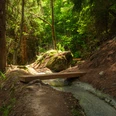
The route starts in the picturesque village of Fieschertal and at first leads without major climbs eastward into the valley towards Unnerbärg. There you follow the signpost to Fiesch Glacier/climbing garden and after about 5 minutes reach the quite steep ascent towards the Aspi-Titter suspension bridge. For this strenuous section you will be rewarded with a view of the Fiesch Glacier. Passing idyllic mountain huts you continue hiking to the Burghütte. The beautifully located hut is the destination of the hike. On the way back you first walk westward and then continue always downhill back to the starting point Fieschertal.
Good to know
Pavements
Best to visit
Directions
Tour information
Loop Road
Stop at an Inn
Equipment
We recommend:
- Good footwear
- Weather-dependent clothing: always carry a waterproof vest
- Headwear
- Sun protection
- Water bottle
- Picnic
- Camera
- Binoculars (optional)
- Hiking poles (optional)
- Printout of the hiking trail (click «Print» to download)
Directions & Parking facilities
Additional information
Furkastrasse 39
CH-3983 Mörel-Filet
+41 27 928 58 58
info@aletscharena.ch
www.aletscharena.ch
Literature
Author´s Tip / Recommendation of the author
Safety guidelines
The use of the hiking trails and information on this website is at your own risk. Conditions on site may cause changes to the route. Aletsch Arena AG assumes no responsibility for the accuracy and completeness of the information on this website.
- Carry a map with you. Download the complete hiking trail description with a large-scale map by clicking «Print» at the top right of the page.
- Use only marked hiking trails and observe all signposts and instructions - for your own safety, the protection of grazing animals, and out of respect for wildlife.
- Close gates after passing through.
- Behave considerately towards other trail users, plants, and animals.
Map
Nearby