


- 0:25 h
- 2.24 km
- 8 m
- 6 m
- 1,339 m
- 1,347 m
- 8 m
- Start: Geschinen
- Destination: Ulrichen, Nordic Center
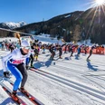
The Funloipe is mainly about having fun. This is guaranteed by almost circular curves and long loops in the deeply snow-covered winter landscape. The fun part: you don’t feel pursued at your back but greet the pursuers friendly from the side glance.
The new 2-kilometer trail strip is laid out between Geschinen and the Nordic Center, Ulrichen. The plain on the left side of the Rhône offers itself excellently for such cross-country skiing enjoyment. The Funloipe can be ideally combined with other trails and adds a lively fresh note to your cross-country skiing day.
Planning the trail preparation must be well thought out with over 100 kilometers of trails. The idea for the Funloipe originated early one morning from the head of technical services while pondering a so-called empty run. Not least, the Corona situation also motivated creating more space for our valued guests.
We wish you lots of fun on the Goms trail.

Good to know
Best to visit
Directions
Equipment
We recommend:
- Good cross-country skiing equipment
- Sun and rain protection as well as warm clothing
- Detailed maps or information material with good route preparation
- Provisions for your day in the open nature
- First-aid kit and mobile phone for emergencies
Directions & Parking facilities
From Brig, follow the cantonal road no. 19 (Furka road) for about 34 km to Geschinen.
Goms is also well connected from the Zurich / Lucerne region via Andermatt - Furka car shuttle train www.matterhorngotthardbahn.ch.
With the regional trains of the Matterhorn Gotthard Bahn, you reach Geschinen from Brig in 1h 11 min. Goms is also easily accessible from the Zurich / Lucerne region via Andermatt - Furka Base Tunnel.
Train and bus timetables can be found at www.sbb.ch.
Additional information
- Winter sports report at www.obergoms.ch/wintersportbericht
- Timetable www.sbb.ch
- Emergency service phone number: 144
- Avalanche bulletin and snow situation at www.slf.ch
Literature
At tourist information points, at sales points of the Goms trail, as well as in most hotels and restaurants in Obergoms, you will find the following brochures:
- Winter map Obergoms with trail plan
- Holiday companion
Author´s Tip / Recommendation of the author
Safety guidelines
The Goms trail is open from 9:00 am to 4:00 pm. Use of the trails is at your own risk. Obergoms Tourism AG as well as the Goms trail disclaim all liability and do not take responsibility for the accuracy and completeness of the information on this website.
Use only marked trails and observe all markings and signs - for your own safety, to protect the landscape, and out of respect for wildlife.
Behave considerately towards other trail users. Every skier must, especially on descents, adjust speed and behavior to their ability and visibility. In classic tracks and on the track for free technique, skiing is done on the right side with an appropriate safety distance to the skier in front. Those who stop step out of the trail. Assistance in case of accidents is a matter of course. To alert emergency services, dial 144.
Weather conditions can change very quickly and without warning in the mountains. Appropriate clothing and sufficient provisions (food and drink) are very important. In unstable weather it is better to return early.
Through the winter sports report you are always well informed about current conditions (avalanche danger, trails, winter hiking trails, snowshoe trails, and road status).
Map
Hiking map Goms, Rotten Verlag, 1:25‘000
Topographic maps 1:25,000 Swisstopo: 1250 Ulrichen
Nearby

