- 5:00 h
- 20.42 km
- 755 m
- 1,034 m
- 760 m
- 1,391 m
- 631 m
- Start: Fiesch, train station
- Destination: Mörel-Filet, train station
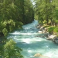
The starting point of the hike is Fiesch. At the Fieschertal/Station junction, hike toward Wiler and at the crossroad in Birchi continue toward Fiescheralp. After a short time, you reach the Laggeraweg, which you follow through meadows and forests to a bridge and the junction to Martisberg. Once the climb to Martisberg is done, the route continues relatively flat: along the sunny valley slope, you pass the idyllic Valais villages Betten Dorf, Goppisberg, and Greich with their typical black larch houses. For the last section—the descent to Mörel-Filet—you have two route options: either walk via Ried-Mörel or via Breiten downhill. Afterwards, you take the train back to Fiesch.

Good to know
Pavements
Best to visit
Directions
Tour information
Stop at an Inn
Equipment
We recommend:
- Good footwear
- Weather-dependent clothing: always carry a waterproof vest
- Headgear
- Sunscreen
- Water bottle
- Picnic
- Camera
- Binoculars (optional)
- Hiking poles (optional)
- Printout of the hiking trail (click «Print» to download)
Directions & Parking facilities
Additional information
Furkastrasse 39
CH-3983 Mörel-Filet
+41 27 928 58 58
info@aletscharena.ch
www.aletscharena.ch
Literature
Author´s Tip / Recommendation of the author
Safety guidelines
Use of the hiking trails and information on this website is at your own risk. Conditions on site may cause changes to the route. Aletsch Arena AG assumes no responsibility for the accuracy and completeness of the information on this website.
- Carry a map with you. Download the complete description of the hiking trail with a large-scale map by clicking «Print» at the top right of the page.
- Use only marked hiking trails and obey all signs and instructions - for your own safety, to protect grazing animals, and out of respect for wildlife.
- Close gates after passing through.
- Be considerate of other trail users, plants, and animals.
Map
Nearby