


- 1:05 h
- 15.22 km
- 35 m
- 1,147 m
- 1,347 m
- 2,494 m
- 1,147 m
- Start: Nufenenpass (2,478 m / 8,136 ft)
- Destination: Ulrichen (1,347 m / 4,419 ft)
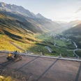
At the start on the Nufenenpass, there is a magnificent view of the snow-covered peaks of the Bernese and Valais Alps. You can already get a first glimpse of the upcoming descent: from above some sections of the trail are clearly visible. At first, the trail makes a detour across the cantonal border into Ticino before continuing on Valais soil. The uppermost section leads through a high alpine landscape: over rocky terrain, past dry stone walls and other relics of Roman times. A look into the distance is worthwhile. Apart from the beautiful view over the whole valley, in good visibility the peaks of the Finsteraarhorn as well as Eiger, Mönch and Jungfrau can be seen in the background. There follow flowy sections over soft alpine meadows and forest ground. They are interrupted by short, more technically demanding sections. The crossings of the Nufenen pass road offer ideal rest pauses.

Good to know
Best to visit
Directions
The trail runs along the mountain stream Ägene and the pass road out of the valley. The fauna and flora change during the descent: At the top of the pass it is often windy and fresh even in high summer; the landscape is rocky and barren. As you go down, it gets warmer and the landscape more colorful, the ground softer and the trail flowier. Upon reaching the valley, follow the Rhone route between Ulrichen and Oberwald. This stage is especially suitable for experienced mountain bikers, as the focus is on enjoying the descent.
Tour information
Cultural Interesting
Equipment
Well-sprung mountain bike with perfect brakes. Cycling gloves, helmet and knee pads at your own discretion. Backpack with repair materials and mobile phone for emergencies.
Directions & Parking facilities
By train (Matterhorn Gotthard Bahn) from Brig in 1 hour 15 minutes to Ulrichen train station.
There is a parking lot in Ulrichen.
By PostBus from Ulrichen.
Runs from late June to mid October (Ulrichen, train station -> Nufenen pass height).
Bike reservation 0848 100 222 mandatory by 4 p.m. the day before.
Additional information
Author´s Tip / Recommendation of the author
After the descent, it is worth stopping at one of the restaurants in Ulrichen.
Safety guidelines
The mountains, a place of joy to share and respect. The mountain world is a place to meet and experience unforgettable moments together – whether by bike or on foot. To ensure that all users can benefit from it, it is essential to share this space with respect for nature and agriculture. Respectful behavior allows everyone to enjoy their leisure activities under the best conditions. Inform yourself about recommendations and rules.
Assess your own skills and fitness well. Riding the various routes is fundamentally at your own risk.
Map
Swiss National Map 1:25 000, sheet 1250 Ulrichen, ISBN: 978-3-302-01250-6
Nearby

