


- 2:30 h
- 6.17 km
- 184 m
- 184 m
- 1,368 m
- 1,565 m
- 197 m
- Start: Oberwald, village
- Destination: Hotel-Restaurant Rhonequelle
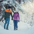
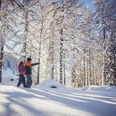
Feel the majesty of the mountains up close – recognize the precious sparkle of the water in the eternal ice. On the way from Oberwald to the Hotel-Restaurant Rhonequelle, winter dreams come true. An unforgettable experience for everyone.

Good to know
Best to visit
Directions
Tour information
Loop Road
Stop at an Inn
Equipment
We recommend:
- Good footwear and hiking poles
- Sun and rain protection as well as warm clothing
- Detailed map or information material with good route preparation
- Provisions for your day in the open nature
- First aid kit and mobile phone for emergencies
Directions & Parking facilities
From Brig, follow cantonal road no. 19 (Furka road) for 40 km to Oberwald. The Goms is also well connected from the Zurich / Lucerne region via Andermatt – Furka car shuttle.
The Alpine passes Furka, Grimsel and Nufenen are closed in winter. Timetables for the Furka car shuttle are available at www.matterhorngotthardbahn.ch
With the regional trains of the Matterhorn Gotthard Bahn, you can reach Oberwald from Brig in 1h 13 min. The Goms is also well accessible from the Zurich / Lucerne region via Andermatt – Furka Base Tunnel. Train timetables can be found at www.sbb.ch
Additional information
- Winter sports report at https://www.obergoms.ch/wintersportbericht
- Timetable www.sbb.ch
- Emergency service phone number: 144
- Avalanche bulletin and snow situation at www.slf.ch
Literature
At tourist information points, at the sales points of the Goms ski track and in most hotels and restaurants in Obergoms, you can find the following brochures:
- Winter map of Obergoms with ski track plan
- Holiday companion
Author´s Tip / Recommendation of the author
Safety guidelines
Use of the winter hiking trails is at your own risk. Obergoms Tourismus AG rejects any liability and assumes no responsibility for the accuracy and completeness of the information on this website.
Carry a hiking map with you or download the complete description of the hiking trail with a large-scale map. Use only signposted paths and heed all markings and signs – for your own safety, to protect the landscape, and out of respect for wildlife. Behave considerately towards other trail users. Take your waste and the waste of others with you.
Weather conditions in the mountains can change very quickly and without warning. Appropriate clothing and sufficient provisions (food and drink) are very important. In case of unstable weather, it is better to turn back early.
Carry additional sun protection. UV rays at high altitude can be very strong, especially in winter, even under cloudy skies.
Plan your tour carefully and thoroughly. Inform yourself in advance about the current conditions (avalanche danger, ski tracks, winter hiking trails, snowshoe trails as well as road conditions) and weather conditions. The winter sports report provides valuable information from the region on this matter.
Map
Nearby
