


- 3:30 h
- 4.58 km
- 820 m
- 22 m
- 1,797 m
- 2,621 m
- 824 m
- Start: Simplon Street, Engeloch
- Destination: Magehorn
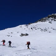
Ascent
Engeloch – Starting at the Engiloch Restaurant (or the car park to the north of it), drive west over the bridge at Chluismatta and cross the Alpstafel and the Ritzibach creek to the northwest. After the Ritzibach, you ascend the wooded ridge to the west. Then turn right (north), cross under the Hotosse and continue to the upper end of the Marchgraben. At the foot of the northern flank of the Galehorn, continue to the Magelicka at 2,439 m. From there climb the southern flank to the summit.
Descent
Engeloch – The descent is via the ascent route. This may vary depending on the risk assessment.

Good to know
Pavements
Best to visit
Directions
Tour information
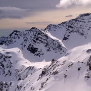
Summit
Equipment
Directions & Parking facilities
Stop: Simplon, Engeloch
Additional information
Questions about the Brig Simplon region: www.brig-simplon.ch
Literature
Author´s Tip / Recommendation of the author
Benefit from the new Simplon snowshoe and ski touring app. Earn points and get great rewards. The app is at www.simplon.ch
Safety guidelines
Rapid changes in weather can occur. Be careful and do not put yourself in danger.
Disclaimer
Walking routes in alpine terrain requires good physical condition, serious preparation and technical knowledge in mountain sports. The ascent of the routes described is at your own risk. Brig Simplon Tourismus AG, SAC and the authors do not assume any liability for the topicality, correctness and completeness of the information provided. Liability claims of any kind against Brig Simplon Tourismus AG or against the authors are excluded.
SOS: 144
Map
Nearby


