- 2:30 h
- 3.81 km
- 1,000 m
- 1,800 m
- 2,621 m
- 821 m
- Start: Engeloch
- Destination: Engeloch
Ascent
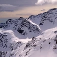
Engeloch – From the Engeloch Restaurant, drive west over the Chrummbach Bridge at Chluismatta. Then traverse the Alpstafel and the slope on the left bank of the Ritzibach creek, up onto the Wysse Bode plateau (2,113 m). At the end of the plateau you will see a steep slope with rocky outcrops. These can be overcome east (left) of the waterfall via the ramp. Cross the Ritzibach above the riegel and ascend towards Sirwoltesattel (2’621 m).
Descent
Simplonpass– The descent is via the ascent route. This may vary depending on the risk assessment. If conditions are good and safe, a racy and steep descent through the Ritzitälli is possible. Bielti / Simplonpass – If conditions are good and safe the descent to the Bielti is also possible. This will require a last ascent (approx. 30 minutes) back onto the Simplonpass at the end of the tour.

Good to know
Best to visit
Directions
Tour information
Loop Road
Equipment
Directions & Parking facilities
Stop: Simplon, Engeloch
Additional information
Questions about the Brig Simplon region: www.brig-simplon.ch
Literature
Author´s Tip / Recommendation of the author
Benefit from the new Simplon snowshoe and ski touring app. Earn points and get great rewards. The app is at simplon.app
Safety guidelines
Rapid changes in weather can occur. Be careful and do not put yourself in danger.
Disclaimer
Walking routes in alpine terrain requires good physical condition, serious preparation and technical knowledge in mountain sports. The ascent of the routes described is at your own risk. Brig Simplon Tourismus AG, SAC and the authors do not assume any liability for the topicality, correctness and completeness of the information provided. Liability claims of any kind against Brig Simplon Tourismus AG or against the authors are excluded.
SOS: 144
Map
Nearby


.JPG")