


- 2:00 h
- 3.55 km
- 471 m
- 7 m
- 1,985 m
- 2,456 m
- 471 m
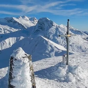
- Start: Simplon Pass
- Destination: Simplon Pass
Ascent
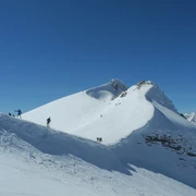
Simplonpass – From the Simplonpass at 2’005 m head west and pass the flat areas at th Hopsche. At approximately 2’200 m turn north-westwards and head right over the ramp of the Gälmji up onto the pass. You will reach the summit over the western ridge.
Descent
Simplonpass – The descent is via the ascent route. This may vary depending on the risk assessment.

Good to know
Pavements
Best to visit
Directions
Tour information
Loop Road
Stop at an Inn
Equipment
Directions & Parking facilities
Additional information
More information about ski tours at: www.sac-cas.ch/de/huetten-und-touren
Questions about the Brig Simplon region: www.brig-simplon.ch
Snowshoe and ski tour map 1: 50,000 is available from the Brig and Simplon tourist office.
274S Visp ISBN number: 978-3-302-20274-7
Literature
Author´s Tip / Recommendation of the author
Benefit from the new Simplon snowshoe and ski touring app. Earn points and get great rewards. The app is available at simplon.app.
Safety guidelines
Disclaimer of liability
Walking on routes in alpine terrain requires good physical condition, serious preparation and technical knowledge in mountain sports. The ascent of the routes described is at your own risk. Brig Simplon Tourismus AG SAC and the authors assume no liability for the topicality, correctness and completeness of the information provided. Liability claims of any kind against Brig Simplon Tourismus AG or against the authors are excluded.
SOS: 144
Map
274S Visp ISBN number: 978-3-302-20274-7
Nearby


