


- 2:00 h
- 4.14 km
- 674 m
- 2 m
- 1,985 m
- 2,648 m
- 663 m
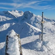
- Start: Simplon, top of the pass
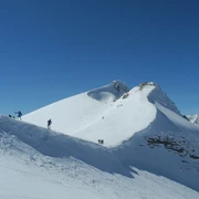
- Destination: Tochuhorn
Ascent
Simplon Pass - You start on the Simplon Pass at 2,005 m and head west, across the plains past the hamlet of Hopsche into the traverse on the southern slope of the Tochuhorn. Later you turn in a north-westerly direction and continue up the valley between Tochuhorn and Straffelgrat (in a zigzag). The wide east ridge is now steep and on foot to the summit.
descent
Simplon Pass - The descent is via the ascent track. Depending on the assessment of the dangers, this can also vary.
Bielti / Simplonpass - In good and very safe conditions, instead of the traverse under the Tochuhorn, the descent down to Bielti is a good idea. At the end, this requires a return to the Simplon Pass of around 30 minutes.

Good to know
Pavements
Best to visit
Directions
Ascent / descent
A) Normal route from Simplon Pass. Difficulty ZS- Ascent / - -descent: 685m | Counter ascent on descent: 16m- Starting -altitude: 1990 m above sea level | Target altitude: 2659 m above sea level
-Time required ascent: 2¼ h | Distance: 2.7 km- Places on the route: Tochuhorn
Ascent / descent
C) from the Simplon Pass. Difficulty WS
-Ascent / descent: 669m | Counter ascent on descent: 0m- Starting
-altitude: 1990 m above sea level | Target altitude: 2659 m above sea level
-Time required ascent: 2¼ h | Distance: 4 km
Other options (without track)
Departure
B) according to Schallberg. Difficulty ZS
-Departure: 1696m | Counter ascent on descent: 328m
-Starting altitude: 2659 meters above sea level | Target
-altitude: 1291 m above sea level
-Lowest point: 1121 m above sea level | Highest point: 2659 meters above sea level
-Time required for departure: 3 h | Distance: 11.2 km
-Places on the route: Lengritz - Schilte - Unners Nesseltal - Guggili (Brig-Glis - VS) - Aspji - Chalchofe (Ried-Brig - VS)
Tour information
Loop Road
Stop at an Inn
Summit
Equipment
Directions & Parking facilities
Additional information
Questions about the Brig Simplon region: www.brig-simplon.ch
Literature
Author´s Tip / Recommendation of the author
Benefit from the new Simplon snowshoe and ski touring app. Earn points and get great rewards. Purchase the app at simplon.app.
Safety guidelines
Rapid changes in weather can occur. Be careful and do not put yourself in danger.
Disclaimer
Walking routes in alpine terrain requires good physical condition, serious preparation and technical knowledge in mountain sports. The ascent of the routes described is at your own risk. Brig Simplon Tourismus AG, SAC and the authors do not assume any liability for the topicality, correctness and completeness of the information provided. Liability claims of any kind against Brig Simplon Tourismus AG or against the authors are excluded.
SOS: 144
Map
Nearby


