- 0:35 h
- 1.79 km
- 101 m
- 100 m
- 680 m
- 781 m
- 101 m
- Start: Naters, Marktplatz
- Destination: Naters, Marktplatz
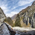
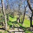
The Way of the Cross begins at the cemetery in Naters and winds its way up the wooded hillside to the prayer chapel “Maria Hilf.” Along the path, 14 small chapels with slate roofs are lined up. Inside, neo-Gothic figurines vividly depict the Passion of Christ – from His condemnation by Pontius Pilate to His crucifixion and burial.
The origin of this Way of the Cross is closely tied to the restoration of the parish church between 1977 and 1980. As part of the renovation, the heritage authorities decided to remove the neo-Gothic Stations of the Cross, dating from 1898, from inside the church.
Since many faithful did not agree with this decision, the idea emerged to relocate the 14 stations outdoors – from the cemetery up to the chapel. The project was carried out in 1982 and 1983 under the direction of the parish council. Around 240 volunteers contributed approximately 10,000 hours of unpaid labor to complete the Way of the Cross as it stands today.
The short circular walk also leads through the historic village center of Naters, past numerous listed buildings and picturesque squares.

Good to know
Pavements
Best to visit
Directions
The hike starts at the market square and leads via the church to Beinhausweg. The route continues to Judengasse and up to the cemetery. From the cemetery up the 14 stations of the Way of the Cross in the forest to the prayer house.
The way back first leads further up. At the fork, turn right and after a short while you will come down to the Klosi. At the Ornavasso tower, follow the left path down to the Old Village and from there back to the market square.
Tour information
Cultural Interesting
Loop Road
Equipment
Sturdy shoes, clothing suitable for the weather, sun and rain protection, as well as sufficient supplies of food and drinks, should there be no refreshment stops or shopping facilities available or open. Although the trail is very well marked throughout, you should always have a suitable hiking map with you for safety reasons. Take sticks or other aids with you.
Directions & Parking facilities
From western Switzerland: A9 Lausanne - Vevey, or north-western Switzerland: A12 Bern - Vevey: A9 - Sierre: main road Sierre - Brig
From north-western Switzerland: A6 Berne - Thun - Spiez: main road Spiez - Kandersteg (Lötschberg tunnel car transport) - Goppenstein - Gampel - Brig
From eastern and central Switzerland: Andermatt - Realp (year-round Furka car transport; in summer via Furka Pass) - Oberwald - Brig
From Ticino (in summer): Airolo - Nufenenpass - Ulrichen - Brig
Or via Centovalli - Domodossola - Simplonpass - Brig
From Italy (Aosta, Mt. Blanc Tunnel): Aosta - Grand Saint Bernard tunnel (over the pass in summer) - Martigny: A9 motorway - Sierre: Sierre - Brig main road.
Or via Domodossola - Simplon Pass - Brig
You can also walk directly from Brig through Naters to start your tour.
Author´s Tip / Recommendation of the author
Enjoy the silence and atmosphere of this place of power.
Safety guidelines
Despite the "impossible to miss" marking of the hiking trails, we recommend for safety reasons to always have an appropriate hiking map with you so that you can quickly find your way to a safe area in case of a thunderstorm or emergency, for example.
Especially in autumn, you should also be aware that leaves lying on the ground can hide bumps, roots, stones or holes in the path. After storms, trees can still fall over or branches can fall down. Especially in adverse weather conditions, muddy and slippery passages can occur on natural paths. You have to expect this kind of damage to paths when you go on a hike.
Not all rocks or precipices are secured with ropes or railings. In some cases surefootedness is required. If you are of the opinion that certain sections of the trail are not passable for you, you should avoid them.
Nearby