


- 2:30 h
- 7.91 km
- 53 m
- 343 m
- 1,878 m
- 2,218 m
- 340 m
- Start: Fiescheralp, cable car mountain station
- Destination: Riederalp, cable car west mountain station
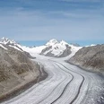
From Fiesch you take the cable car up to the Fiescheralp. From there, hike westwards. On the level path, you reach Bättmer Hitta via Laxeralp. From now on, it goes downhill: after a short walk you reach Bettmeralp and cross the village to the cable car mountain station at the western edge of the village. Along the way, you pass the chapel Maria zum Schnee and typical Valais chalets. From the edge of the village, you hike on the Aletsch Promenade towards Riederalp West. After leaving the beautiful mountain forest behind you, you enter open terrain: the impressive panoramic views of the Mischabel group, the Matterhorn, Weisshorn, down into the Rhone valley and to Riederalp West are now your constant companions. From Riederalp, take the cable car down to Mörel and the train back to Fiesch. Note: the section Bettmeralp – Riederalp is paved and illuminated at night. It can also be done well in the late evening.

Good to know
Pavements
Best to visit
Directions
Tour information
Stop at an Inn
Equipment
We recommend:
- Good footwear
- Weather-dependent clothing: always carry a waterproof vest
- Headgear
- Sunscreen
- Water bottle
- Picnic
- Camera
- Binoculars (optional)
- Trekking poles (optional)
- Printout of the hiking trail (click "Print" to download)
Directions & Parking facilities
Additional information
Furkastrasse 39
CH-3983 Mörel-Filet
+41 27 928 58 58
info@aletscharena.ch
www.aletscharena.ch
Literature
Author´s Tip / Recommendation of the author
Safety guidelines
Use of the hiking trails and information on this website is at your own risk. Conditions on site may cause changes to the route. Aletsch Arena AG assumes no responsibility for the accuracy and completeness of the information on this website.
- Carry a map with you. Download the complete description of the hiking trail with a large-scale map by clicking "Print" at the top right of the page.
- Use only marked hiking trails and observe all signs and instructions – for your own safety, to protect grazing animals, and out of respect for wildlife.
- Close gates again after passing through.
- Be considerate of other trail users, plants, and animals.
Map
Nearby

