- 3:10 h
- 6.54 km
- 1,104 m
- 1,109 m
- 2,212 m
- 1,103 m
- Start: Fieschertal
- Destination: Fiescheralp
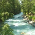
The starting point of the hike is the Fieschertal playground. Cross the Wysswasser and then follow the path, which winds up through the forest toward Bärg. Once there, the route continues steeply in switchbacks up to Matt. At the height of Geissbode, you have completed most of the ascent (around 1,100 meters elevation). On the last section, you now hike over the relatively flat path directly across the sun plateau westward to the Fiescheralp. From there, you take the aerial cableway down to Fiesch and then continue by post bus back to Fieschertal.

Good to know
Pavements
Best to visit
Directions
Equipment
We recommend:
- Good footwear
- Weather-dependent clothing: always carry a waterproof vest
- Headwear
- Sun protection
- Water bottle
- Picnic
- Camera
- Binoculars (optional)
- Trekking poles (optional)
- Printout of the hiking trail (click "Print" to download)
Directions & Parking facilities
Additional information
Furkastrasse 39
CH-3983 Mörel-Filet
+41 27 928 58 58
info@aletscharena.ch
www.aletscharena.ch
Literature
Author´s Tip / Recommendation of the author
Safety guidelines
Use of the hiking trails and information on this website is at your own risk. Conditions on site may cause changes to the route. Aletsch Arena AG assumes no responsibility for the accuracy and completeness of the information on this website.
- Carry a map with you. Download the complete description of the hiking trail with a large-scale map by clicking "Print" at the top right of the page.
- Use only marked hiking trails and observe all signs and instructions - for your own safety, to protect grazing animals, and out of respect for wildlife.
- Close gates after passing through.
- Be considerate to other trail users, plants, and animals.
Map
Nearby