- 1:00 h
- 1.71 km
- 356 m
- 1,998 m
- 2,355 m
- 357 m
- Start: Simplon Hospiz
- Destination: Panettone
Ascent
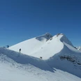
Simplonpass – Follow the old line of the former skilift from the Simplon Hospiz or Kulm to the top station. Then continue diagonally along the pleasant north-west slopes towards the east to the large, striking black boulder “Panettone” at approx. 2’380 m. The Panettone stands out clearly from the northwest ridge of the Hübschhorn and is marked with a small cross.
Descent
Simplonpass – The descent is via the ascent route. This may vary depending on the risk assessment.

Good to know
Best to visit
Directions
Tour information
Loop Road
Stop at an Inn
Equipment
Directions & Parking facilities
Stop: Simplon Hospiz, Hospiz
Additional information
Questions about the Brig Simplon region: www.brig-simplon.ch
Literature
Author´s Tip / Recommendation of the author
Ski tourers feel at home on the Simplon. Spend the night in one of the hotels on the pass or in the village and spend a few days touring in the region.
Benefit from the new Simplon snowshoe and ski touring app. Earn points and get great rewards. The app is at simplon.app.
Safety guidelines
Safe skiing, alpine, quite difficult tour. Only accessible in very safe conditions, and you do so at your own risk.
Rapid changes in weather can occur. Be careful and do not put yourself in danger.
Disclaimer
Walking routes in alpine terrain requires good physical condition, serious preparation and technical knowledge in mountain sports. The ascent of the routes described is at your own risk. Brig Simplon Tourismus AG, SAC and the authors do not assume any liability for the topicality, correctness and completeness of the information provided. Liability claims of any kind against Brig Simplon Tourismus AG or against the authors are excluded.
SOS: 144
Map
Nearby