


- 3:00 h
- 9.53 km
- 251 m
- 251 m
- 672 m
- 923 m
- 251 m
- Start: Brig, station
- Destination: Brig, station
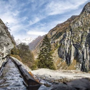
The route leads through the old town of Brig to the nature trail "Achera Biela" and across the Biela to Ried-Brig. After a village tour through old Ried-Brig, it descends into the Brig recreational area, the Grindji. From here, you return along the Saltina to the centre of Brig.

Good to know
Pavements
Street
Trail
Path
Best to visit
suitable
Depends on weather
Directions
The route leads through the old town of Brig to the nature trail "Achera Biela" and across the Biela to Ried-Brig. After a village tour through old Ried-Brig, it descends into the Brig recreational area, the Grindji. From here, you return along the Saltina to the centre of Brig.
Tour information
Cultural Interesting
Loop Road
Stop at an Inn
Equipment
Weather-appropriate equipment is essential. Good, sturdy hiking boots are strongly recommended for all hikes.
Directions & Parking facilities
By train, post bus, or private vehicle to Brig.
There is a parking garage at the station.
Brig is easily accessible by train or post bus. Along the hike, there are various post bus stops available.
Additional information
Literature
Cultural guide to geography, history, economy, language and culture. Brig-Glis, Naters and Ried-Brig. Editor Volmar Schmid, Publisher: Wir-Walser, Visp, 2001.
Author´s Tip / Recommendation of the author
On the hike, you will learn a lot about the Valais villages. Enjoy a gelato on the sunny terraces of the restaurants along the way.
Safety guidelines
Hiking is at your own risk. Insurance is the responsibility of the hiker.
Map
Hiking maps are available at the tourism office in Brig.
Nearby


