


- 1:30 h
- 10.55 km
- 46 m
- 856 m
- 1,352 m
- 2,206 m
- 854 m
- Start: Grimselpass, Grimsel Pass summit stop
- Destination: Obergesteln, train station
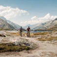
Anyone who likes to steer their bike on agile downhill rides will feel at home on the Grimsel Trail. The over 800 meters of elevation are to be overcome not uphill, but downhill for once.
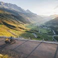
The start is at the Grimsel Pass summit. Right at the starting point a magnificent Alpine panorama invites you to take a moment to enjoy the enchanting view of the Bernese Alps and the precious water catchment area of the Grimsel region.
Passing the legendary Totensee, you reach the highest point of the tour at about 1.5 km at 2206 m above sea level. Again, a magnificent view invites you to stop. Here the countless peaks of the Valais Alps present themselves up to the world-famous Matterhorn. Far below in the valley, the young Rhone winds through the fertile valley floor of the Goms.
Then off you go! The long descent leads through various vegetation zones to the endpoint in Obergesteln. On this path (Via Sbrinz), heavily loaded mule trains also moved southwards for centuries.

Good to know
Pavements
Best to visit
Directions
Grimselpass - Twäregg - Nassbode - Unnerbrunnji - Jungstafel - Grimselchäller - Mangel - Obergesteln
Tour information
Cultural Interesting
Stop at an Inn
Equipment
We recommend:
- Technically flawless bike or bicycle with a bell
- Bicycle helmet and gloves
- Sun and rain protection as well as warm clothes
- Detailed map or information materials with good route preparation
- Provisions for your day in the outdoors
- First aid kit and mobile phone for emergencies
Directions & Parking facilities
From Brig follow the cantonal road no. 19 (Furka road) for 40 km to Oberwald. From there follow route no. 6 for 6 km to the Grimsel Pass summit.
The Goms is also well connected from the Zurich / Lucerne region via Andermatt - Furka car shuttle.
With the regional trains of the Matterhorn Gotthard Bahn you can get from Brig to Oberwald in 1h 23 min. The Goms is also well accessible from the Zurich / Lucerne region via Andermatt - Furka Base Tunnel.
Change in Oberwald to the PostAuto Grimselpass line to the Grimsel Pass summit stop.
The timetables of trains and buses can be found at www.sbb.ch.
Additional information
- Summer report at www.goms.ch
- Timetable www.sbb.ch
- Emergency service phone number: 144
Literature
In the tourist information offices as well as in most hotels and restaurants in Obergoms you will find the following brochures:
- Obergoms summer map with hiking, cycling and bike paths
- Holiday guide
Author´s Tip / Recommendation of the author
The mountain bike experience by Roland Stauder in Switzerland. 127 km and 4,700 spectacular meters of elevation - peaks, glaciers, great feelings.
Safety guidelines
Use of bike and bicycle paths is at your own risk. Obergoms Tourismus AG rejects all liability and assumes no responsibility for the accuracy and completeness of the information on this website.
Carry a bike map with you or download the complete description of the bike path with a large-scale map. During your route, it is advisable to use only marked paths and roads. Respect the rules of Swiss road traffic and observe all signposts and instructions - for your own safety, to protect the landscape, and out of respect for wildlife. Behave considerately towards other path users. Take your waste and that of others with you.
The weather conditions in the mountains can change very quickly and without warning. Appropriate clothing and sufficient provisions (food and drink) are very important. In case of unstable weather, it is better to turn back early.
Carry additional sun protection. UV rays at high altitudes can be very strong, even under cloudy skies.
Plan your route carefully and thoroughly. Inform yourself in advance about current conditions and weather. The summer report provides valuable information about the region.
Map
- Hiking map Goms, Rotten Verlag, 1:25,000
- Topographic maps 1:25,000 Swisstopo: 1250 Ulrichen
Nearby
