- Photos & Map
How would you like to arrive?
- Description
- Good to know
- Nearby
Download GPX file
- 1:30 h
- 4.70 km
- 151 m
- 151 m
- 1,826 m
- 1,975 m
- 149 m
- Start: Rosswald, mountain station
- Destination: Rosswald, mountain station
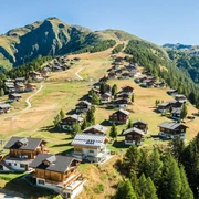
On Rosswald three circular hiking trails for walkers and hikers were built. The routes are marked in three colours.
- Blue: Mountain Water Circular Path
- Red: Saflischwald circular trail
- Green: Rosswald circular trail
In this hike you follow the blue signposts. From the mountain station you hike up to the parking lot. Then continue on a wide forest road in the direction of "Stafel". Follow the well signposted path until you reach the Wasserleite. Now walk along the little stream. After the beautiful, pleasant hike you come back to the Rosswald.
Good to know
Pavements
Best to visit
Directions
Tour information
Loop Road
Equipment
Directions & Parking facilities
Additional information
Author´s Tip / Recommendation of the author
Safety guidelines
Map
Nearby


