


- 4:00 h
- 9.60 km
- 702 m
- 703 m
- 2,047 m
- 2,418 m
- 371 m
- Start: Alpe Laghetto
- Destination: Andolla
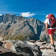
8th stage: In the shadow of Andolla
From Alpe Laghetto, you ascend to the Campo lakes, a series of water surfaces located below the slopes of Monte Straciugo, the highest peak of the Bognanco valley. From the Pontimia Pass, from which you have a view of the peaks of the Upper Bognanco valley and the Zwischbergen valley, you then enter the plateaus that stretch up to below the Andolla Pass. You walk along the picturesque lakes of Pontimia, through the ruins of the mountain huts of the namesake Alpe, across meadows with views of the rugged peaks of Andolla and Weissmies. From the Andolla Pass, you then reach the Antrona valley by descending into the valley basin that extends towards the Andolla Alps.

Good to know
Pavements
Best to visit
Directions
Equipment
Directions & Parking facilities
Additional information
Further hiking information can be found at: www.simplon.ch
Author´s Tip / Recommendation of the author
Safety guidelines
Nearby

