- 3:30 h
- 10.06 km
- 62 m
- 1,205 m
- 903 m
- 2,048 m
- 1,145 m
- Start: Andolla
- Destination: Antrona
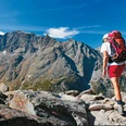
9th stage: between ibex, deer, and roe deer
At the Andolla shelter, ibex can often be observed in the evening hours. To descend to Cheggio, you can either use the normal road or one that leads to Alpe Camasco (restored in 2013), where you enter the area of deer and roe deer, the park of the Antrona valley. In Campalamano, there is a Tibetan bridge and, if you continue the hike, you will come across the chapel of Piana Ronchelli. Then continue along the characteristic Cavallisee. Cheggio is a small settlement built around a small oratory dedicated to St. Bernard. Later, you descend over the pastures of Campo to Antrona.

Good to know
Pavements
Best to visit
Directions
Equipment
Directions & Parking facilities
You can reach Domodossola by train from Brig. In Domodossola, take the bus to Antreno Schieranco.
From Antreno Schieranco, hike about 1h 30min to Rifugio Andolla, where the hike starts. Alternatively, you can drive a private car to the reservoir and start the hike from there.
You can reach Domodossola by train from Brig. In Domodossola, take the bus to Antreno Schieranco.
From Antreno Schieranco, hike about 1h 30min to Rifugio Andolla, where the hike starts.
Additional information
More hiking information can be found at: www.simplon.ch
Safety guidelines
Nearby