


- 7:00 h
- 20.79 km
- 613 m
- 1,968 m
- 672 m
- 2,601 m
- 1,929 m
- Start: Simplonpass, postal bus stop
- Destination: Brig, train station
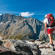
The start of this challenging and long route is at the Simplonpass. The path passes Alpstafel Hopsche and begins to climb slowly. On the plain between Nanzlicka and Tochuhorn you pass by the Undre Rossusee, a small mountain lake. This is followed by a short and intense ascent to the Üsseri Nanzlicka, the highest point of the entire route. Allow yourself a rest here, as the path down into the Nanztal is exhausting. Once you arrive at the bottom of the Nanztal, you walk alongside the stream "Gamsa" downstream. Along the right side of the valley, the path runs above the water to Schratt and from there to Holzji.

Good to know
Pavements
Best to visit
Directions
Equipment
Directions & Parking facilities
Author´s Tip / Recommendation of the author
Safety guidelines
Map
Nearby


