- 5:00 h
- 18.69 km
- 762 m
- 723 m
- 1,889 m
- 2,485 m
- 596 m
- Start: Visperterminen, Giw chairlift
- Destination: Simplon Hospice
The chairlift takes you from Visperterminen to the Giw mountain station. Here begins the steepest ascent of the hike to the Gibidumpass. Be sure to take a short break at Gibidum Lake. The lake serves as a water reservoir and simultaneously feeds the well-known Heido irrigation channel. Originally, the upper and lower Heido channels served to irrigate the meadows of Visperterminen; today only the upper channel is still in operation. Since 1916, water has been led directly from the Nanztal valley to Visperterminen through a 2.65-kilometer-long tunnel beneath Gibidum.
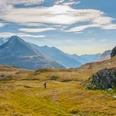
The hike follows the course of the irrigation channel from Gibidumpass and leads to the back of the original and only on foot accessible Nanztal valley. Alternatively, you can descend directly from Gibidumpass towards Bististafel – the path is shorter but significantly less pleasant to walk due to the descent and ascent compared to the further path to the valley end. The Nanztal runs from south to north and lies between the Visper valley and the Simplon Pass.
At the upper Fulmoos, you cross the Gamsa river and ascend again on the east flank of the Nanztal towards Bistinepass. From here, the day's goal, the Simplon Pass with its mighty stone eagle, is already in sight. The monument was built during the active time in World War II. As a symbol of vigilance, it was erected in memory of the “Watch at Simplon” by Mountain Brigade 11.
The final descent from the pass height to Blatte overcomes about 500 meters in altitude, before you reach the Simplon Pass from Blatte via a short ascent.
Highlights of the hike:
- Gibidum Lake and the historic Heido irrigation channel for watering the meadows and vineyards of Visperterminen.
- The romantically wild and natural Nanztal valley.

Good to know
Pavements
Best to visit
Directions
Tour information
Cultural Interesting
Stop at an Inn
Equipment
We recommend:
- Good footwear
- Weather-dependent clothing: always carry a waterproof vest
- Headwear
- Sunscreen
- Water bottle
- Picnic
- Camera
- Binoculars (optional)
- Trekking poles (optional)
- Printout of the hiking trail (click “Print” to download)
For certain hikes:
- Swimsuit
Directions & Parking facilities
Highway A9 and cantonal road 9 to Visp. Follow the signs to Visperterminen and drive on Terbinerstrasse via Unterstalden and Oberstalden to Visperterminen.
Additional information
Further information about the destination:
Literature
Author´s Tip / Recommendation of the author
Take a detour to the scenic Gibidum Lake. Due to the shallow depth of the mountain lake, swimming is possible in summer.
Safety guidelines
The mountains, a place of joy to share and respect. The mountain world is a place to meet and experience unforgettable moments together – whether by bike or on foot. For all users to benefit, it is essential to share this space with respect for nature and agriculture. Respectful behavior enables everyone to enjoy their leisure activities under the best conditions. Inform yourself about recommendations and rules. Assess your own abilities and fitness well. Traveling on the various routes is always at your own risk.
For all hikes:
- Carry a map with you. Download the complete description of the hiking trail with a large-scale map by clicking “Print” at the top right of the page.
- Use only marked hiking trails and observe all signs and instructions – for your own safety, to protect grazing animals and out of respect for wildlife.
- Close gates after passing through.
- Behave considerately towards other trail users, plants, and animals.
For mountain hikes:
- Carry additional sun protection. UV rays at high altitudes can be very strong, even in cloudy weather.
- Plan your hike carefully: consider the fitness level required for all participants, weather forecasts, and seasonal dependencies.
- Weather conditions can change very quickly and without warning in the mountains. Appropriate clothing and sufficient provisions (food and drink) are very important. In unstable weather, it is better to turn back early.
For high-alpine hikes:
- Inform your family about your hiking route. If possible, avoid going alone.
- Do not venture onto glaciers without a mountain guide.
- Observe warning signs indicating dangers at riverbanks, along watercourses below dams and reservoirs: water level can rise quickly and without warning.
Map
Nearby