


- 7:00 h
- 23.46 km
- 928 m
- 821 m
- 1,889 m
- 2,483 m
- 594 m
- Start: Gspon
- Destination: Simplon Pass
4th stage: accompanied by the Eida.
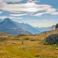
Continuing along this panoramic path at 2000 to 2300 meters altitude, you reach the Gebidum Pass, which is located above the village of Visperterminen. It is famous for its vineyards. Here is the basin fed by an old canal, the “Biss,” also called Eida. The Eida itself carries the water from the Fletschhorn Glacier. Thus, you now enter the Nanztal along the “Biss,” with a picturesque view of the valley and the steep face of the Fletschhorn. In Obers Fulmoos, you then walk on the other side of the valley and thus reach the Bistine Pass, from where you enter the Simplon Valley, with views of Monte Leone (the highest mountain of the Lepontine Alps).

Good to know
Pavements
Best to visit
Directions
Equipment
Directions & Parking facilities
Gspon is well accessible by public transport.
By train to Stalden-Saas, by cable car to Stalden-Ried, and from there by cable car to Gspon.
Gspon is well accessible by public transport.
By train to Stalden-Saas, by cable car to Stalden-Ried, and from there by cable car to Gspon.
Additional information
For more information, visit: www.simplon.ch
Safety guidelines
Nearby


